
Please click on the map,
the region you want to visit |
|
|
|
|
| |
|
 |
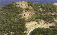
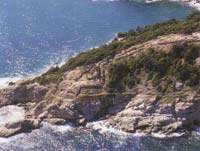
Ancient Stagira, the birthplace of Aristotle |
|
THE POSITION OF ANCIENT STAGIRA
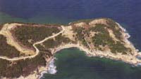
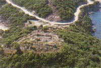
 Ancient Stagira located about 500 meters southeast of the current settlement of Olympiada, on a small, mountainous and beautiful peninsula called "Liotopi". The city occupied the two hills of this peninsula, i.e. the coastal North and a greater South, which are separated by a low strip of land. The location of the city, which is known as the birthplace of Aristotle, it is both identified with certainty from the reports of the ancient writers, and by the investigations of modern scholars.
 The ancient evidence is clear:
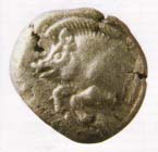
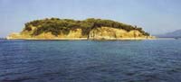
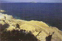
They give the distance of this city from the ancient Acanthos southern, state that was seaside and, most importantly, most of the time talking about a small island opposite Stagira, bearing the name "Kapros". (The same name is given to the port of the ancient city, probably identical to the bay of Olympiada, while the coins of Stagira shown one Kapros (boar)). The only island that actually exists in the region is the current "Kafkanas", which is only 1.5 miles from the ancient city. Today it is uninhabited and attracts all the gulls of the area, but the ruins there indicate that it had been inhabited from the classic up to the Middle Byzantine years. Most characteristics of the ruins are the two large water tanks and a building from the Byzantine period located on the west coast of the island.
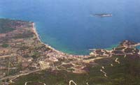
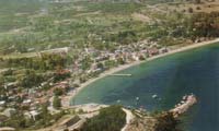 It is a small but beautiful village of 650 inhabitants, built by refugees who came from St. Kyriaki of Asia in 1923. When the refugees settled there, found a village with about 10 farming families. The small area that allocated to them was swampy and plagued by malaria. Because of the disease was lost the 1/3 of the original refugee population, while much of them dispersed to other regions of Macedonia and Thrace.
According to a local tradition, the name comes from Olympiada, the mother of Alexander, who, by the king Cassandros, had been exiled at Ancient Stagira or at the nearby island "Kapros". Although the information is unconfirmed, it is conceivable to hide some historical truth.
 Today the village, built along a beautiful beach, is stretched in the recess of a natural harbor. It is surrounded by lush mountains and beautiful beaches in a great combination, which attracts many visitors especially during the summer months.
Each summer also, on celebration of the patron Saint Kyriaki, there are organized cultural and artistic events, with subjects of the life and work of the great philosopher Aristotle.
In Ancient Stagira, that is located southeast of Olympiada, the excavations began in 1990 with a funding from the European Union and the Ministry of Culture, and with the participation of the Community of Olympiada. Since then and until 2000 there were researches every summer.
Supervising authority is the 16th Prehistoric and Classical Antiquities of Thessaloniki, with director the Archaeologist Dr. Sismanides Costas.
HISTORICAL DATA FOR STAGIRA
 The city was founded around 655 BC by Iones colonists of Andros Island, and later arrived settlers from Chalkis.
After the Persian wars, Stagira was a member of the Athenian Alliance, contributing to the common fund.
However, during the Persian Wars, namely in 424 BC, the city renegaded from the Athenians and made an alliance with Spartans. That angered the Athenians, who were rushed to encircle the city, but without a result.
 Later Stagira joined the Chalkidean League, the confederation of all the cities of Chalkidiki, which was established at Olynthos.
In 349 BC the city was besieged and then yielded to the king of Macedonia Philip II, who destroyed it completely, but he reinstated it a few years later, in honour of Aristotle.
But it seems that this disaster by Philip already marked the beginning of the decline of the city, which started to decline continuously. Thus, the geographer Stravon, who lived at the time of Jesus Christ, notes that during his era, Stagira was already deserted.
A thousand or so years later, the existence of a small medieval castle is indicating in the same position, which bore the name "Livasdias" and later "Lipsasda". At this castle belongs, obviously, the few buildings at the top of the North Hill as the Byzantine wall which closing up the same hill.
Also, we delivered the information that in Classic years, Stagira bore and the name Orthagoria, but that view is incorrect, mainly because a city of that name existed near Maronia of Thrace.
ARISTOTLE
The birthplace of Aristotle.
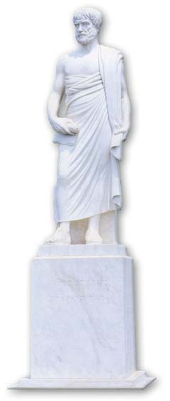 He was born in Stagira in 384 BC. His father was Nicomachos, the physician of King Amyntas II and his mother was Faistis or Faistias. His parents died early and the care of young Aristotle took the Proxenos, a relative from Atarnea, a city of Mysia. At the age of 18 years he came down from Stagira to Athens, where he attended for 20 years in the Platonic Academy, i.e. until the death of Plato in 347 BC.
Shortly before, Aristotle had established a school in Assos of Troada as a branch of the Academy. Then he married Pythiada from Atarnea. He stayed in the area of Troada for 3 years and then went to Lesvos, where he friendly linked to Theophrastos, and later left him as a successor of the school of Athens. He stayed in Lesvos for 2 years, i.e. until 343 BC, when he was invited by Philip II as a teacher of his son Alexander.
The education of Alexander lasted 3 years, i.e. until 340 BC. Then Aristotle retired in Stagira, where he remarried, this time with his compatriot Cherfyllida (or Erpyllida). He returned to Athens in 335 BC, when he founded his own school, the Lykio, which later named Peripatos. He led this school for 12 years, during which occurred his wondrous work.
After the death of Alexander, he was accused by his enemies "for blasphemy" and fled to Chalkis, where he had an estate, inherited from his mother. There in Chalkis and at age of 63 years, died one year later, in 322 BC. He left two children, Pythiada and Nicomachos.
According to a later literary tradition, one year after the death of Aristotle in Chalkis, the Stagiritians officially transferred and buried his bones in the city. It is reported that it was a magnificent ceremony, and it was created a great altar to the tomb of the philosopher and established in his honour an annual festival, the "Aristotelia". Today there are efforts for the revival of this great celebration of "Aristotelia". The first art exhibitions were already took place in the summer of 1996 and they were very successful.
THE HISTORY OF EXCAVATIONS
Before starting the excavations in ancient Stagira, only the traces of the medieval occupation were visible at the North Hill (especially the Byzantine partitions), while from the oldest city of Stagira, only minor traces were distinguished within the dense jungle vegetation. It is in honour of the Community Councils of Olympiada, that for years, it was striving to convince the Archaeological Service, to start excavations in the homeland of Aristotle.
 A first, small-scale excavation and for a short-time effort undertaken in 1968 by the director of the Museum of Thessaloniki, F. Petsa. Then researches conducted at two points outside the fortified city: in the bay of "Sykia&, where uncovered the retaining walls of the classical period and in "Vina" (about 1.5 kilometers southeast of the ancient Stagira), where came revealed a circular tower.
The reason for this effort was the discovery of a particular half statue of Kouros, which brought up by an individual diver in the gulf of "Liotopi". It took more than 20 years since that first excavation attempt to resume with a more systematic way,(the excavations in Stagira. The launch is conducted by the writer of this report, the archaeologist Dr. Sismanides Kostas), with pilot and exploratory incisions in September 1990. The very encouraging results of that research created the favorable conditions for the continuation of excavations that conducted regularly for a decade.
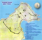
TOUR IN THE ARCHAEOLOGICAL SITE
An important tool for the visitor of the ancient Stagira is the topographical chart on the next image (Click on it to view it in a larger dimension). Based to this chart and its accompanying text, we are starting the tour
of the site:
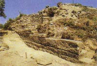
- Early classical fortification: In the period of its high prosperity, i.e. from 500 BC until approximately mid-4th century BC, the city was protected by a strong fortification wall, the total length of which is estimated at around 2 km.
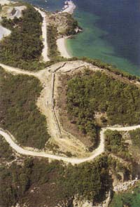 It is a magnificent work of the architecture of fortification, dated around 500 BC. Feature is the fact that apart from the south side of Stagira, where the wall clogged the city from sea to sea, at the other three sides, it goes always parallel and along the precipitous coast. Its route is traced in the entire perimeter of the city, but a full disclosure of the fortification has been, until now, only at the southern part, and in large parts of eastern, western and northern part of it, to a total length of 700 m. approx. This wall has a thickness of 2 m and is built of limestone and marble stones, with various building systems, the main of which are, except the irregular system, the so-called Egyptic system, the "Lesvion" system (which occurs in a large part of the southern part of the fortifications) and the Polygonal, an important part of which was discovered in the extreme northern point of the hill immediately above the steep cliff. The wall is maintained in excellent condition (some parts are saved up to 4 m. in height) and its foundations are incrementally inside the rock along the steep slopes of a mountainous terrain. To two parts so far, one corresponding to the southern and one to western part, small gates are uncovered and at mid-points, there are opened culverts to remove rainwater. Especially in the southern part of it and in normal distances between them, there are large circular and square towers. So far they have come to light three such circular towers and as many square towers. Similarly, in various points within the front wall, there are large rectangular and compact stone constructions. These are known as staircases, stairs leading to the ramparts of the wall. We note here that, in the context of a broader It is a magnificent work of the architecture of fortification, dated around 500 BC. Feature is the fact that apart from the south side of Stagira, where the wall clogged the city from sea to sea, at the other three sides, it goes always parallel and along the precipitous coast. Its route is traced in the entire perimeter of the city, but a full disclosure of the fortification has been, until now, only at the southern part, and in large parts of eastern, western and northern part of it, to a total length of 700 m. approx. This wall has a thickness of 2 m and is built of limestone and marble stones, with various building systems, the main of which are, except the irregular system, the so-called Egyptic system, the "Lesvion" system (which occurs in a large part of the southern part of the fortifications) and the Polygonal, an important part of which was discovered in the extreme northern point of the hill immediately above the steep cliff. The wall is maintained in excellent condition (some parts are saved up to 4 m. in height) and its foundations are incrementally inside the rock along the steep slopes of a mountainous terrain. To two parts so far, one corresponding to the southern and one to western part, small gates are uncovered and at mid-points, there are opened culverts to remove rainwater. Especially in the southern part of it and in normal distances between them, there are large circular and square towers. So far they have come to light three such circular towers and as many square towers. Similarly, in various points within the front wall, there are large rectangular and compact stone constructions. These are known as staircases, stairs leading to the ramparts of the wall. We note here that, in the context of a broader 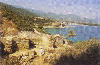 study, which was drafted by a team of architects, the restoration program of this southern part of the fortification it began in 1995. Among other places, some restoration works were carried out in large parts of the wall, right and left respectively of the hill, at the circular tower immediately to the right and at the large square tower, about 50 meters east. The interventions specific to these two towers are relatively of big scale, because they are going to be the viewing points for visitors. study, which was drafted by a team of architects, the restoration program of this southern part of the fortification it began in 1995. Among other places, some restoration works were carried out in large parts of the wall, right and left respectively of the hill, at the circular tower immediately to the right and at the large square tower, about 50 meters east. The interventions specific to these two towers are relatively of big scale, because they are going to be the viewing points for visitors.
- Citadel: It is occupied the high plateau, at the top of the southern hill. In plan view, shows a rectangle triangle, whose
 south side is identical to the classic wall that passing through this point. In this side and next to the large circular tower on top of the hill, there is the small gate we saw, and around and stuck inside the wall there is a staircase with seven steps. The other two sides of the citadel fortress protected by a separate enclosure, the inner side of which and in between regular distances (every 3 m.), there are stone buttresses in a row. The small rectangular spaces created by the struts in the entire length of the wall were probably roofed, as shown by the large storage jars found in several of these areas. Inside the citadel and directly opposite the gate of the wall, ii has discovered a circular water tank with a diameter of 2 and a depth of 4 m. south side is identical to the classic wall that passing through this point. In this side and next to the large circular tower on top of the hill, there is the small gate we saw, and around and stuck inside the wall there is a staircase with seven steps. The other two sides of the citadel fortress protected by a separate enclosure, the inner side of which and in between regular distances (every 3 m.), there are stone buttresses in a row. The small rectangular spaces created by the struts in the entire length of the wall were probably roofed, as shown by the large storage jars found in several of these areas. Inside the citadel and directly opposite the gate of the wall, ii has discovered a circular water tank with a diameter of 2 and a depth of 4 m.
At its highest corner, also came to light a square area, with side 5 m. This area, along with a second similar alongside, was a military outpost to monitor the surrounding area of Stagira. It occupies the highest point of the whole city in general, with the ability of sighting of both areas, this and its surroundings, in large radius.
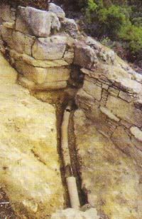 Central hydro-tube: It penetrates the wall at a point of its south part. There are have unearthed 45 meters of it so far. It comprises of clay-pipelines in a row that lower the water from the big mountain in the south of the ancient city. Here and along a modern forest road, there are many such clay-pipelines. We do not know the exact route of the pipelines in the city, but we hope that future research will lead us to the central water reservoir. Central hydro-tube: It penetrates the wall at a point of its south part. There are have unearthed 45 meters of it so far. It comprises of clay-pipelines in a row that lower the water from the big mountain in the south of the ancient city. Here and along a modern forest road, there are many such clay-pipelines. We do not know the exact route of the pipelines in the city, but we hope that future research will lead us to the central water reservoir.
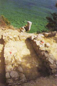
- Classical Hellenistic houses: These sections of stone houses of the 5th, 4th and 3rd centuries BC, excavated at many different points of the city. As expected, the earliest evidences of habitation come from the North Hill, where came to light and the most important ruins of the residential architecture of Stagira. It is found that the mountainous terrain, the steep slopes and the density of habitation often require different practical solutions, such as, for example, the flattening of the natural rock and the creation of stepped terraces, on which were built blocks or individual houses. Also, the gradients of soil often impose a tiered configuration, even in rooms of the house itself, and at the same time, are helping the creation of the underground spaces, which usually have a storing or a laboratory use.
The houses that were examined so far provide us with significant information about the settlement organization, the domestic economy 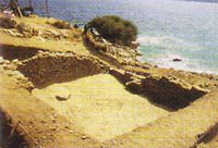 and the society of Stagira. Built with various sizes of carved stones or not, houses usually have floors of soil. The large rooms are impressive, and so are and the narrow streets between them, that are either stone-paved or landscaped in the rock. This fact and the phased order of the houses, reminiscent of the traditional villages of the Greek islands. and the society of Stagira. Built with various sizes of carved stones or not, houses usually have floors of soil. The large rooms are impressive, and so are and the narrow streets between them, that are either stone-paved or landscaped in the rock. This fact and the phased order of the houses, reminiscent of the traditional villages of the Greek islands.
- Water tank: It is located on the top site between the two hills of the city, where, according to the excavation evidences, were built also and its public buildings. It is a small rectangular tank of water, built with huge good-carved quoins and paved floor. In its original form, the entire inner surface, it was coated with a thick sheet of lead.
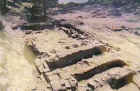
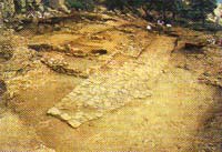
 Gallery of classic years: A public building, located downtown, i.e., where there is placed the market. This is an important, rectangular and oblong building, where Stagirians were gathering for public debates. Its dimensions are 6X26m. and it is built mainly with marble quoin. The access within was done via a monumental stair in the front, which we must imagine it unroofed with columns in a row. The other three walls have inside a simple stone seat (bench). To support the roof they had a colonnade interior, with eight columns in the middle of its width, of which only the marble bases are retained. In front of the gallery and on the left of the stairs, was saved the foundation of a small altar with a circumferential groove flooding, carved in the rock. Gallery of classic years: A public building, located downtown, i.e., where there is placed the market. This is an important, rectangular and oblong building, where Stagirians were gathering for public debates. Its dimensions are 6X26m. and it is built mainly with marble quoin. The access within was done via a monumental stair in the front, which we must imagine it unroofed with columns in a row. The other three walls have inside a simple stone seat (bench). To support the roof they had a colonnade interior, with eight columns in the middle of its width, of which only the marble bases are retained. In front of the gallery and on the left of the stairs, was saved the foundation of a small altar with a circumferential groove flooding, carved in the rock. 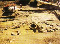
- Remains of ancient buildings: are preserved only the foundations of a circular and of two rectangular buildings, dating back to the 6th century BC, i.e. an era earlier than the era of the gallery, which is right northern. From the same era are the remain buildings that have been uncovered at the corresponding left side of the facade of the gallery, along with two large quoins which were probably the base of some monuments.
 Paved road and public building: From the right end of the gallery, is beginning a stone-paved road, which, following an oblique path 20m to the south, encountered a second vertical paved road. The road was uncovered in length of about 30 m. so far, i.e. as much as the public building that is located immediately right to the north and along its banks. The halls of this assembly that are organized behind a common facade were probably undergrounded. A remarkable fact, which is connected with the operation of the buildable area, is the flattening of the natural rock, at different scaling levels. Paved road and public building: From the right end of the gallery, is beginning a stone-paved road, which, following an oblique path 20m to the south, encountered a second vertical paved road. The road was uncovered in length of about 30 m. so far, i.e. as much as the public building that is located immediately right to the north and along its banks. The halls of this assembly that are organized behind a common facade were probably undergrounded. A remarkable fact, which is connected with the operation of the buildable area, is the flattening of the natural rock, at different scaling levels.
Until now, have been identified three such levels: closest to the gallery and at the highest level, there is a tripartite structure, 12 m. in height. 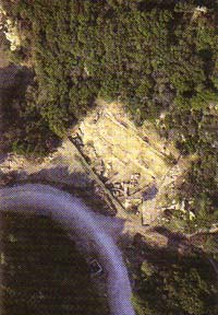 The excavation evidence shows that there was here some of the traditional stores. Immersed in the earthen floor, were found parts of three huge jars and a large clay pan, all welded joints with lead right from the time of their placement, which means that were intended not for liquids, but for solid products, maybe cereal. The excavation evidence shows that there was here some of the traditional stores. Immersed in the earthen floor, were found parts of three huge jars and a large clay pan, all welded joints with lead right from the time of their placement, which means that were intended not for liquids, but for solid products, maybe cereal.
The second in the row large rectangular area of the complex is on a considerably lower level. In its western half, were discovered two large and oblong deep structures (like boats), near and parallel, in a row and carved into the rock, having at their bottom five shallow cavities. These cavities, as much as a large number of pits beside them, are also carved in the rock, making likely the view that in this area was operated a large warehouse. In this sense, the numerous pits in the area (hidden by some height) there must been large storage jars for various agricultural products.
At the third and lowest level of this row, is formed, in similar size, a rectangular space, which was used also as storage. So, there was here one of the public warehouses of the city, and it was also accommodated in the basement of the same complex.
 Byzantine Wall: It is clogged the North Hill from sea to sea, and it is almost straight. Its length is about 250 m., thickness of 1 m., and is preserved to a height of 3.5 m. It is irregular built with stones and mortar. Occasionally, there are stone buttresses at its inner side. Its construction dates back to the Middle Byzantine period (10th-11th century AD) and is associated with the installation of a Byzantine fortress, on the top of that hill. Byzantine Wall: It is clogged the North Hill from sea to sea, and it is almost straight. Its length is about 250 m., thickness of 1 m., and is preserved to a height of 3.5 m. It is irregular built with stones and mortar. Occasionally, there are stone buttresses at its inner side. Its construction dates back to the Middle Byzantine period (10th-11th century AD) and is associated with the installation of a Byzantine fortress, on the top of that hill.
- Byzantine tower - Archaic wall and gate - arched building - Marbled floor:
 In the middle of the path of the Byzantine wall and at its highest point, has been discovered a large square tower, and several others, particularly important architectural relics. The walls of the Byzantine tower, which are kept at a high altitude, are built with nice-curved quoins of oldest buildings, which are inserted in its simplest wall with small stones and plaster. Next to this tower and on the right, the last part of the first fortifications of the city came to light, dating back to the Archaic period (6th century BC). This proved that the line of the ancient wall is just the same with that of Byzantium. It was found that the Byzantine wall, which is bounded the north hill to top, uses as base exact this ancient wall. This fact is particularly important, mostly for the extend of the town since its inception (7th cent. BC) until the early 5th century BC, when the population growth required it to extend to the neighbouring South Hill, with the construction of the early classical fortification we saw. At the small section of the ancient wall that is excavated so far, came to light and one of the main gates of the oldest of the cities, Stagira, where in front of it, it was even found fallen and broken the marble lintel. This lintel must have a total length of about 2.50 m., and the most important is the fact that it has an anaglyph boar on the left, faced up to a lion on the right. Of this image were found only its two side sections, which is also known to decorate and the tetra-drachms of Stagira. This finding is particularly important not only because it gives us a large piece of archaic art, nor because it represents the sacred animal which is the symbol of the city of Stagira, i.e., the boar (let's remember here that the name "boar" brought both the port of the city and the island opposite), but also because it saves parts of an circular inscription of the 6th century BC. In the middle of the path of the Byzantine wall and at its highest point, has been discovered a large square tower, and several others, particularly important architectural relics. The walls of the Byzantine tower, which are kept at a high altitude, are built with nice-curved quoins of oldest buildings, which are inserted in its simplest wall with small stones and plaster. Next to this tower and on the right, the last part of the first fortifications of the city came to light, dating back to the Archaic period (6th century BC). This proved that the line of the ancient wall is just the same with that of Byzantium. It was found that the Byzantine wall, which is bounded the north hill to top, uses as base exact this ancient wall. This fact is particularly important, mostly for the extend of the town since its inception (7th cent. BC) until the early 5th century BC, when the population growth required it to extend to the neighbouring South Hill, with the construction of the early classical fortification we saw. At the small section of the ancient wall that is excavated so far, came to light and one of the main gates of the oldest of the cities, Stagira, where in front of it, it was even found fallen and broken the marble lintel. This lintel must have a total length of about 2.50 m., and the most important is the fact that it has an anaglyph boar on the left, faced up to a lion on the right. Of this image were found only its two side sections, which is also known to decorate and the tetra-drachms of Stagira. This finding is particularly important not only because it gives us a large piece of archaic art, nor because it represents the sacred animal which is the symbol of the city of Stagira, i.e., the boar (let's remember here that the name "boar" brought both the port of the city and the island opposite), but also because it saves parts of an circular inscription of the 6th century BC.
The large square Byzantine tower is surrounded of a public arched structure (dimensions 9X10 m.) that gives the initial impression of a tower of the archaic wall we saw. However, a careful observation of the findings, is convinced us that this structure, although is built with good construction material (which comes from ancient public buildings), belongs to the early Hellenistic period.
For the time being, its functionality remains a problem.
Inside the Byzantine, and consequently, and inside the ancient wall, behind of the archaic gate we saw, but eccentrically and obliquely with respect to the axis of both this and the other buildings in the same area, is discovered a large rectangular marbled floor. In the centre of the marble slab there is a small rectangular area, empty nowadays, where is likely to be initially erected there a small shrine of the 6th century BC.
- Byzantine fortification wall - Byzantine tower and cistern:
As mentioned above (see No. 9), at the large flat, approximately one-acre area that is created on top of the North Hill, was installed during the middle Byzantine period, a military fort. Apart the Byzantine wall, which, as we saw, clogged the entire hill, this fort was protected by a separate fortification wall, thickness of 1 m., which is maintained at a high altitude. In its plan is presented a trapezoidal shape and reinforced with internal struts, while, outside, with square or circular towers and tower-like structures. Inside the enclosure are visible the remains of a rectangular building, probably a Byzantine tower. Immediately next to it and to the east, is preserved in good condition, a large, rectangular water tank (Byzantine cistern) with side about 5 meters, which has an internal coating of hydraulic mortar.
Beneath this mortar are distinguished many, and huge, carefully carved granite quoins, similar with many others that are built-in in all the Byzantine buildings.
- Archaic Temple: he nice-curved granite quoins, we just mentioned, it is proved that came from a large and rather archaic hecatompeda Temple (6th century BC), which began to be excavated at the top of North Hill. Until now it has discovered a length of 30 m., only one of its long walls, which is maintained to a height of 2.20 m. And other architectural elements of the church have discovered, but still very fragmentary, because the excavation has not been completed. Important, however, for the character of the temples, is among other things, the several pieces of architectural sculpture. Some of them are the large marble cornice with palmette and lotus flowers alternately and others of a huge Ionic column. In the sculptural decoration of the temple there is also a part of a bearded male face and a small head of exceptional Ionic art.
 After-classic Wall: It is located on the north-eastern slopes of the North Hill. It is uncovered, until now, at a length of 140 m. In its lower part has a crooked line route, which is become straight higher. Compared to the earlier classic wall, parts of which were discovered a little lower (just above the Precipice coast), this seems to be the older part of a town. Its thickness is 1.80 m., preserved to a height of 3 meters and is irregularly built. In the middle of its route, there is a small gate. As revealed by the excavation, it is the wall built by Philip II, after he had destroyed the city in 349 BC. According to sources, the reconstruction of Stagira by Philip was at the request of the Aristotle, who had meanwhile been hired as a teacher of Alexander. Periodically and inside of the front wall, there are transverse walls, which, together with the flattening of the rock, are creating scaled residential: terraces. Especially, at the highest part of the wall in contact with the inner side, came to light lately, several rectangular buildings, that are, mainly, parts of houses of the Hellenistic years. After-classic Wall: It is located on the north-eastern slopes of the North Hill. It is uncovered, until now, at a length of 140 m. In its lower part has a crooked line route, which is become straight higher. Compared to the earlier classic wall, parts of which were discovered a little lower (just above the Precipice coast), this seems to be the older part of a town. Its thickness is 1.80 m., preserved to a height of 3 meters and is irregularly built. In the middle of its route, there is a small gate. As revealed by the excavation, it is the wall built by Philip II, after he had destroyed the city in 349 BC. According to sources, the reconstruction of Stagira by Philip was at the request of the Aristotle, who had meanwhile been hired as a teacher of Alexander. Periodically and inside of the front wall, there are transverse walls, which, together with the flattening of the rock, are creating scaled residential: terraces. Especially, at the highest part of the wall in contact with the inner side, came to light lately, several rectangular buildings, that are, mainly, parts of houses of the Hellenistic years.
 Archaic Sanctuary: This is a small shrine of the 6th century BC, which was dedicated to a female deity. It is located in the northest part of North Hill, just above the steep cliff. It consists of two quadrilateral areas, right and left respectively to a paved runway. Characteristic of the sanctity of the site is the fact that the after-classic wall, which was built about two centuries later, respected it and included it, and for this reason had adjust its route at this place. Most important is the largest area of the sanctuary, where there is a primitive altar and a square grid for sacrifices. From this area come many mobile finds, including many clay figurines of women and big busts, and a clay matrix with the representation of two men who fight for a ram. Archaic Sanctuary: This is a small shrine of the 6th century BC, which was dedicated to a female deity. It is located in the northest part of North Hill, just above the steep cliff. It consists of two quadrilateral areas, right and left respectively to a paved runway. Characteristic of the sanctity of the site is the fact that the after-classic wall, which was built about two centuries later, respected it and included it, and for this reason had adjust its route at this place. Most important is the largest area of the sanctuary, where there is a primitive altar and a square grid for sacrifices. From this area come many mobile finds, including many clay figurines of women and big busts, and a clay matrix with the representation of two men who fight for a ram.
- Ancient circular building: It is at the same age with the Sanctuary and is within walking distance to it. It is maintain in a short height, half about of its perimeter, which is built with stone marble and limestone. Its diameter is 11 m., and as shown by the shape, the size, and from the other findings, it was an altar dedicated to the goddess Demeter.
|
Source: Perfecture authority of Chalkidi
Dr. Kostas Sismanides |
|
|